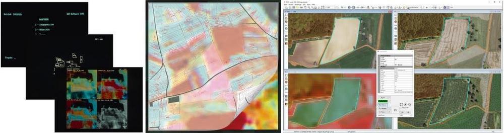
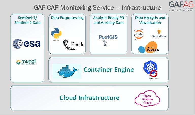
. – GAF Webportal ermöglicht behördenübergreifende Bereitstellung sehr hochauflösender Satellitendaten über die Servicestelle Fernerkundung am Bundesamt für Kartographie und Geodäsie – GAF stellt das hochmoderne GAFportal auf der Intergeo 2022 vor: Halle 2, Stand A2.006 Ein umfangreicher Rahmenvertrag erweitert die erfolgreiche Zusammenarbeit der GAF mit dem Bundesamt für Kartographie und Geodäsie (BKG Bund). Das von […]
continue reading
Satellite data help to detect artisanal mining – GAF AG develops the „ASM Alert“ web platform
GAF has developed and implemented an easy-to-use web-based system to recognise indications of unlicenced artisanal and small-scale mining (ASM) in tropical forests – the “ASM Alert” platform. The platform combines free and publicly available satellite data – in particular European Copernicus Sentinel imagery – with a number of other geodata layers and machine-learning for the […]
continue reading
GAF AG appointed project lead for the Land Rights Administration Modernisation Programme – PROMOGEF in Senegal
A consortium under the lead of GAF AG will implement the “Programme de Modernisation de la Gestion Foncière” (PROMOGEF), the Land Rights Administration Modernisation Programme of the Senegalese Government and the German Federal Ministry for Economic Cooperation and Development (BMZ), funded via the KfW Development Bank. The programme supports the provision of a decentralised, efficient, […]
continue reading
GAF AG nommé chef de projet pour le Programme de Modernisation de la Gestion Foncière – PROMOGEF au Sénégal
Un consortium dirigé par GAF AG mettra en œuvre le "Programme de Modernisation de la Gestion Foncière" (PROMOGEF), programme du gouvernement sénégalais et du ministère fédéral allemand de la coopération économique et du développement (BMZ), financé par la banque de développement KfW. Le programme soutient la mise en place d’une gestion des droits fonciers décentralisée, […]
continue reading
Copernicus Land Monitoring Service: Consortium of GAF, GeoVille and VITO starts HighResolution Layer Vegetated Land Cover Characteristics Project
The European Environment Agency (EEA) recently awarded a contract to a consortium under the lead of GAF with the partners GeoVille and VITO to implement the new High-Resolution Layer (HRL) Vegetated Land Cover Characteristics (VLCC), as part of the pan-European Copernicus Land Monitoring Service (CLMS). Its rich product portfolio will ensure both the continuation and […]
continue reading
25 years of successful cooperation between GAF AG, DLR and Antrix
GAF, the German Aerospace Center (DLR) in Neustrelitz and Antrix Corporation have a successful cooperation stretching back 25 years. In 1996, they signed agreements for the purpose of receiving Indian Earth observation data and distributing the data to European customers on an exclusive basis. That was the starting point for 25 years of successful cooperation […]
continue reading
European VHR2021 project to support Copernicus is now launched
By combining its skills, experience and expertise, the Airbus-GAF consortium will optimise the acquisition of data using a unique fleet of satellites. In the project, the Airbus optical satellite range, consisting of Pléiades, SPOT and Vision-1, as well as the WorldView, GeoEye, Deimos, SuperView, Kompsat and TripleSat satellites, will be used. The consortium will provide […]
continue reading
GAF has been awarded a Multi-Year contract by the German Federal State of Saxony-Anhalt
GAF AG has won the first European call for tenders for the operational implementation of the agricultural area monitoring system in Germany in 2021 stipulated by the European Common Agricultural Policy (CAP). The Paying Agency makes use of GAF’s sophisticated cloud-based solutions for the automatic monitoring of agricultural parcels. The contract runs for the next […]
continue reading
GAF erhält Mehrjahresvertrag von Sachsen Anhalt
Sachsen-Anhalt hat einen Mehrjahresvertrag mit der GAF zur Durchführung des Monitorings landwirtschaftlicher Flächen im Rahmen der Gemeinsamen Agrarpolitik (GAP) in der EU abgeschlossen. Die GAF AG hat den Zuschlag für die erste europaweite Ausschreibung zur hochautomatisierten Auswertung von Satellitendaten in Deutschland hinsichtlich der Überwachung landwirtschaftlicher Flächen im Rahmen der Europäischen Gemeinsamen Agrarpolitik (GAP) erhalten. Der […]
continue reading
GAF AG und BKG intensivieren ihre Kooperation im Hinblick auf die Bereitstellung von Multi-Source-Fernerkundungsdaten
Die GAF AG, einer der größten europäischen Anbieter von Geoinformationsdiensten mit dem Schwerpunkt Erdbeobachtung, hat eine internationale Ausschreibung des Bundesamts für Kartographie und Geodäsie (BKG) für die Bereitstellung von Fernerkundungsdaten gewonnen. Der daraufhin abgeschlossene Rahmenvertrag beinhaltet Beratungsdienstleistungen und Exklusivzugriff für das BKG und deren Bedarfsträger auf hochauflösende und sehr hochauflösende optische Satellitenbilder sowie Radaraufnahmen. Mit […]
continue reading